
Cycling Route Planner
Plan your cycling route, check the weather along the ride and find the best time to set off.
Plan a cycling route
Weather along the ride
Best time to start
Export GPX
01
Plan a cycling route in minutes
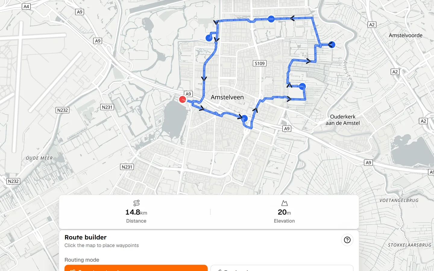
A cycling route planner should get you onto the map immediately. Choose a starting point, add destinations or waypoints, and follow cycling-friendly roads. Adjust the line if a junction or climb isn't what you wanted, then read the distance and elevation before you save.
Tailwind already supports this workflow: draw on the map, snap to roads or draw freehand, save the route, and export GPX when you want it on a head unit. You can start without an account, then save the route when you are ready.
- Choose your starting point
- Add destinations and waypoints
- Follow cycling-friendly roads
- Adjust the route as you go
- See distance and elevation
- Save it, then export GPX
02
Don't just plan where you ride. Plan when you ride.
Most route planners stop at the line on the map. That is only half the ride. The same 60 km loop can feel completely different at 8am and 11am. A westerly wind might make the outward leg easy in one departure window and turn the return into a headwind slog in another.
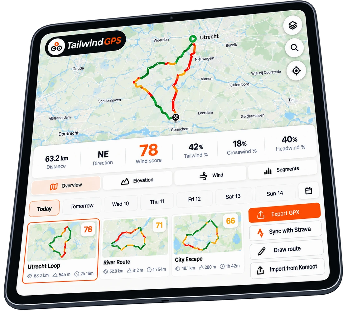
Tailwind builds a Tailwind Score for the whole cycling route for every hour you might leave, using wind, rain, temperature and your expected pace. You are not comparing two weather apps and guessing. You are looking at one number for this route at this time.
03
See the weather along your cycling route
A forecast for your house is not a forecast for your ride. Tailwind samples wind direction, tailwind, headwind, crosswind, rain and temperature along the route, then weights those readings by where you will actually be at your riding pace.
That is why a cycling route planner with weather along the route is a different tool from a pin on a weather map. The score is calculated across the ride, not only at the start point.
- Wind speed and direction
- Tailwind, headwind and crosswind share
- Rain along the route
- Temperature
- Rider pace, so timing matches your ride
04
Find the best time to start your ride
Once the route is on the map, Tailwind shows a Tailwind Score for every departure hour. Pick the window that will actually feel best — then leave.
05
Build, import or find your route
You do not have to start from a blank map. Tailwind gives you three ways into a scored cycling route.
Build it
Draw directly on the map. Snap to cycling roads or switch to freehand where the router cannot follow.
Import it
Upload a GPX from an event, a club captain, or another planner you already use.
Sync it
Connect Strava and pull in the loops you already ride. They get hourly scores without rebuilding.
06
Export your route to your bike computer
When you have the route and the hour, take it with you. Tailwind supports GPX export and route sharing, so you can send the file to a Garmin or Wahoo, or share a link with someone who just needs the line and the score.
Plan in the browser, export GPX, ride on the device you already trust.
07
Why Tailwind GPS?
Plenty of apps can draw a cycling route. Fewer will tell you when that route will actually be nicest to ride. Tailwind sits between a conventional cycling route planner and a route-weather tool: create the route, then optimise the conditions.
| Feature | Tailwind | Typical route planner |
|---|---|---|
| Cycling route creation | ✓ | ✓ |
| GPX export | ✓ | ✓ |
| Route sharing | ✓ | ✓ |
| Strava import | ✓ | ✓ |
| Wind along route | ✓ | Limited |
| Weather along route | ✓ | Limited |
| Best departure time | ✓ | Rare |
| Route score by hour | ✓ | Rare |
| Pace-aware scoring | ✓ | Rare |

Free forever on 3 routes
Stop guessing. Ride with the wind.
- Every route scored for wind, rain and temperature
- The best hour to ride, up to 3 days out
- Strava routes in with one tap
Free forever on 3 routes. No card.
Keep planning with Tailwind GPS
Cycling wattage calculator
Estimate watts from speed, wind, grade and position — then see the formula.
Weather along my route
See why a start-point forecast is not enough for a moving rider.
Bike route planner
A simpler, more casual planner if you just want to go for a ride.
Cycling routes
Browse curated routes by place, then score them for the week ahead.
How it works
How Tailwind Score, pace and hourly forecasts fit together.
Frequently asked questions
What is the best cycling route planner?
The best cycling route planner depends on the job. If you want discovery and huge route libraries, tools like Komoot are strong. If you want to plan a cycling route and know when to ride it — wind, rain and temperature along the line, scored hour by hour — Tailwind GPS is built for that workflow.
What is the best free cycling route planner?
Tailwind GPS is a free cycling route planner to start: draw or import a route, see distance and elevation, and get hourly weather scores on up to three saved routes with a three-day forecast. No app download is required.
How do I plan a cycling route?
Open the map, drop a start point, add waypoints, and follow cycling-friendly roads. Check distance and elevation, save the route, then scroll departure hours to pick the best time. You can also upload GPX or connect Strava instead of drawing.
Can I export a cycling route to Garmin?
Yes. Export the route as GPX from Tailwind and send it to Garmin Connect, or to a Wahoo via the Wahoo app. Shared route links also include a GPX download.
Can I plan a cycling route with GPX?
Yes. Upload a GPX to import an existing course, then score it hour by hour. When you are ready to ride, download GPX again for your bike computer.
How does a cycling route planner work?
You plot start, finish and waypoints. The planner routes along roads or paths and reports distance and elevation. Tailwind then samples forecast weather along that line at your pace, so each departure hour gets a Tailwind Score from 0–100.
How do I plan a cycling route around the weather?
Do not stop at the forecast for your postcode. Load the route in Tailwind, then compare hourly scores. The hour with the best mix of wind, rain and temperature along the ride is the one to leave.
Why stop at planning the route?
Plan your cycling route free, then pick the hour that will actually feel best to ride.