Best road bike routes in London 2026: 10 free GPX loops
Ten curated road cycling loops from the Tailwind GPS London library — distances, elevation, free GPX downloads, and wind-scored departure times.

If you've only got a Sunday morning window or a full day to play with, the question is always the same: where do you actually go for a good road ride in London? Not just a route that looks decent on paper, but one that feels great on the day you ride it.
This guide answers that. Below you'll find 10 curated road cycling loops from the Tailwind GPS London route library — all free to view, all available as GPX downloads, and all scored hour by hour for wind conditions. Each entry uses the verified distance and elevation from the library so you can match the ride to your available time.
Then, once you've found a route you like, we'll show you how to pick the right departure hour so you're not grinding into a headwind the whole way home.
Pick your ride type first
Before diving into the list, here's a quick decision frame:
- Quick loop: Chigwell forest loop (52.8 km) or Richmond Park outer loop (69.3 km with low elevation)
- Training lap with hills: South London lanes east loop (75.8 km / 815 m) or Fackenden Lane ridge loop (71.4 km / 902 m)
- Long hills day: Leith Hill ridge loop (95 km / 837 m) or Isle of Wight east loop (104.9 km / 1,113 m)
- Longer scenic day trip: Beaulieu north loop (70.8 km / 452 m) or Toot Hill woods loop (67.9 km / 621 m)
Some of these are nearer London loops. Others are longer day-trip classics that sit in the London library because that's how London-based road riders actually plan weekends — train out, ride big, come home.
The 10 best road bike routes in London (with GPX)
| # | Route | Distance | Elevation | Link |
|---|---|---|---|---|
| 1 | Toot Hill woods loop | 67.9 km | 621 m | Open |
| 2 | Chigwell forest loop | 52.8 km | 382 m | Open |
| 3 | St Albans park loop | 67 km | 625 m | Open |
| 4 | Eltham palace outer loop | 66.9 km | 486 m | Open |
| 5 | South London lanes east loop | 75.8 km | 815 m | Open |
| 6 | Beaulieu north loop | 70.8 km | 452 m | Open |
| 7 | Richmond Park outer loop | 69.3 km | 213 m | Open |
| 8 | Fackenden Lane ridge loop | 71.4 km | 902 m | Open |
| 9 | Isle of Wight east loop | 104.9 km | 1,113 m | Open |
| 10 | Leith Hill ridge loop | 95 km | 837 m | Open |
1. Toot Hill woods loop — 67.9 km / 621 m
A solid mid-distance route rolling through Essex countryside north-east of London. The elevation is steady rather than brutal, with a mix of exposed lanes and sheltered hedgerow roads. Good for cyclists who want something more interesting than a park lap without committing to a full day in the hills. Wind exposure on the open sections makes departure timing useful here.
2. Chigwell forest loop — 52.8 km / 382 m
The shortest route in the London library and the best option when time is tight. Starting from east London's outer edges, this loop takes you through quiet lanes near Chigwell and the Epping Forest fringe. At 52.8 km with modest climbing, most riders can complete it in under two hours. A strong easterly headwind can make the return leg a slog — exactly the kind of thing a pre-ride Tailwind Score flags before you leave.
3. St Albans park loop — 67 km / 625 m
Heading north out of London toward Hertfordshire, this 67 km loop takes in the lanes around St Albans before looping back. Rolling terrain, a manageable elevation profile, and decent road surfaces make it a popular choice for club rides and solo training days alike. The route works well in either direction depending on prevailing wind.
4. Eltham palace outer loop — 66.9 km / 486 m
A south-east London loop that gets you out of the city surprisingly quickly via quieter roads through Eltham and into Kent. At 486 m of elevation it's undulating without being mountainous. A good option for riders based in south-east London who want a structured loop with a clear start and finish.
View Eltham palace outer loop →
5. South London lanes east loop — 75.8 km / 815 m
This is the route for riders who want a proper workout without travelling far. At 815 m of climbing across 75.8 km, it's one of the more demanding entries in the London library. The lanes south of the city deliver consistent climbing and descending on roads that are generally quieter than the main A-roads. If you want to train effectively in headwinds or just push yourself on a weekday morning, this loop delivers.
View South London lanes east loop →
6. Beaulieu north loop — 70.8 km / 452 m
A longer day-trip option that pushes further south and west. At 452 m of elevation it's one of the more manageable longer routes, making it a good choice for building distance without excessive climbing. Treat this as a proper day-trip classic from the London library — not an inner-city spin.
7. Richmond Park outer loop — 69.3 km / 213 m
Richmond Park is the classic west London training ground, and for good reason. The paved perimeter is popular for repeatable efforts, and the Tailwind GPS library loop extends beyond the park itself into the surrounding road network so you get proper training distance. Because the loop changes direction relative to the wind throughout, checking departure hours makes a real difference to how the ride feels.
View Richmond Park outer loop →
8. Fackenden Lane ridge loop — 71.4 km / 902 m
The hilliest route of the ten. At 902 m of climbing across 71.4 km, Fackenden Lane in the North Downs delivers a proper workout in a compact distance. This Surrey Hills-adjacent loop gives you sharp, punchy climbs without needing to travel as far as Box Hill or Leith Hill. Budget at least three to four hours.
View Fackenden Lane ridge loop →
9. Isle of Wight east loop — 104.9 km / 1,113 m
The big one. At 104.9 km and 1,113 m of climbing, this Isle of Wight loop is the standout day-trip classic in the London library. Factor in ferry crossings and travel time — this is a full-day commitment. Wind matters a lot on exposed coastal stretches; getting departure timing right on a route this long is where route-specific weather forecasting pays off most obviously.
View Isle of Wight east loop →
10. Leith Hill ridge loop — 95 km / 837 m
Leith Hill is the Surrey Hills route that London-based road cyclists return to again and again. At 95 km with 837 m of climbing, it's a serious day out but not an extreme one. For riders comfortable at this distance, it's one of the best rides in the south-east. Because wind direction shifts throughout a route of this length, Strava route planner vs wind-aware planning explains why a static weather app won't tell you which hour to leave.
How to choose the right route for the day
Finding a route is the easy part. Choosing when to ride it is where most people leave enjoyment on the table.
- Distance and time window. Be honest. A 95 km route on a two-hour morning window doesn't work.
- Elevation. Check the metres of climbing, not just the distance. Fackenden (902 m) and South London lanes (815 m) take longer per kilometre than Richmond Park (213 m).
- Traffic stress. Routes near the city are busier before 9am and on weekend mornings. Park-based routes like Richmond avoid the worst of it.
- Surface quality. London-area roads vary. On skinny road tyres, rural North Downs lanes need more caution than a well-maintained park perimeter.
- Rain risk. Wet roads change descending safety on hilly routes like Leith Hill and Fackenden.
- Headwind vs tailwind. This is the one most people ignore and then regret.
On point six: Tailwind GPS assigns every route a Tailwind Score from 0 to 100 for each departure hour. A score of 80–100 means favourable tailwinds for most of the ride. Below 40, expect a tough time. The score accounts for wind direction relative to every segment of your actual route, weighted by your riding speed.
Free accounts cover a 3-day forecast window with up to 3 saved routes. Subscribers unlock a 14-day planning window, up to 40 saved routes, and route-specific alerts.
How to get the GPX and score your departure hour
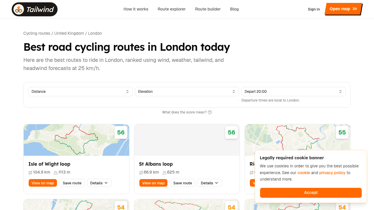
- Open the London hub
- Filter by distance or elevation if you need to narrow the list
- Preview a loop on the map
- Download the GPX (free — no paywall on library downloads)
- Save the route and compare Tailwind Scores across departure hours on the map
You can also draw your own cycling route, upload a GPX, or connect Strava so your regular London loops score automatically.
Browse London routes
Ten curated road loops with maps, elevation, free GPX downloads, and wind-scored departure times.
FAQ
Are these routes suitable for a road bike?
Yes. All 10 routes in the Tailwind GPS London library are curated for road bikes. Fackenden Lane and the South London lanes routes include some sections with variable surface quality — if you're on very narrow tyres (23 mm or below), expect occasional rough tarmac on rural stretches.
Do I need Strava to use Tailwind GPS?
No. Strava sync is the quickest start, but you can upload a GPX directly or draw a route on the map. All three methods get the same hourly wind scoring.
What's the best time of day to ride in London for wind?
It depends on the route and the day. A westerly that helps on the outbound leg of Leith Hill can become a brutal headwind on the return if you leave at noon instead of 8am. The Tailwind Score for each departure hour answers that for your specific loop — see wind-aware hard and easy days for how to use it in training.
Where should I start if I want hills without complicated navigation?
Leith Hill ridge loop or Fackenden Lane ridge loop are the strongest choices from this list. For train access into the Surrey Hills, Leith Hill is the classic option.
Get the GPX and score your departure hour
All 10 routes are free to browse and download at the Tailwind GPS London cycling routes hub. Filter by distance or elevation, open any route on the map, download the GPX, then compare Tailwind Scores across departure hours before you commit to a start time.
The free plan covers three saved routes and a three-day forecast window — enough to feel how much difference choosing the right hour makes.
Related posts

Best cycling routes near me: how to find, score and navigate
Nearby is not the same as best. Find cycling routes near you, score the hour, then start in-browser turn-by-turn in Tailwind GPS — or export GPX to a head unit.
·8 min read

What makes a good cycling route? Distance, climbs, wind and navigation
Distance and elevation are not enough. Check roads, climbs, wind along your actual line, and whether you can follow it — then pick the departure hour with a Tailwind Score.
·10 min read

Best road bike routes in Amsterdam 2026: 10 free GPX loops
Ten curated road cycling loops from the Tailwind GPS Amsterdam library — distances, elevation, free GPX downloads, and wind-scored departure times.
·3 min read