Tailwind GPS vs Outdooractive for cycling routes (2026)
Comparing Tailwind GPS and Outdooractive for cyclists? See which app wins on wind scoring, route planning, offline maps, and pricing. Find the right tool for your rides.

You've got a two-hour window on Saturday morning. You want to ride, but you'd rather not spend the whole thing grinding into a headwind. So you open your favourite app and ask the only question that really matters: will this route feel great at the time I can actually leave?
How each app answers that question is where Tailwind GPS and Outdooractive part ways entirely.
Quick verdict: which one should you use?
Before getting into the detail, here's the short version:
- Choose Tailwind GPS if your priority is knowing when to leave, which route will feel best, and getting a single, actionable wind-aware score per departure hour.
- Choose Outdooractive if you want a full outdoor route planning and navigation platform with offline maps, official topo layers, and multi-activity support.
- Use both if you plan routes in Outdooractive and want to layer in wind/timing intelligence before you head out.
- Outdooractive's weather tools require Pro+ (€59.99/year), so factor that in if weather is your main reason for considering it.
- If you only check one thing before you head out, make it whether the wind is going to be with you or against you on your actual route, not just at your postcode.
| Feature | Tailwind GPS | Outdooractive |
|---|---|---|
| Wind-aware route scoring | Yes (0–100 per hour) | No |
| Departure-hour recommendations | Yes | No |
| Route planning / waypoints | Yes | Yes |
| GPX import/export | Yes | Yes (Pro) |
| Offline maps | No (browser-first) | Yes (Pro+) |
| Official topo maps | No | Yes (Pro+) |
| Weather layers | Route-specific score | Map layer (Pro+) |
| Strava sync | Yes | Limited |
| Free tier | Yes (3-day forecast, 3 routes) | Yes (limited) |
| Subscription cost | $2.99/mo or $19.99/yr | €29.99/yr (Pro), €59.99/yr (Pro+) |
What each app is actually built for

Tailwind GPS is a cyclist-specific planning tool. It exists to answer one question: given the routes I ride, when should I go? Every route you save receives a Tailwind Score (0–100) for every departure hour, based on wind direction, wind speed, temperature, rain probability, and your expected position along the route at each point in time. That last part matters more than it might seem. A rider doing 25 km/h reaches the exposed hilltop stretch at a different time than one doing 18 km/h, so the score is personalised to your pace, not an average.
The scoring scale is: 80–100 = Excellent, 55–79 = Great, 40–54 = Neutral, 20–39 = Challenging, 0–19 = expect a tough ride.
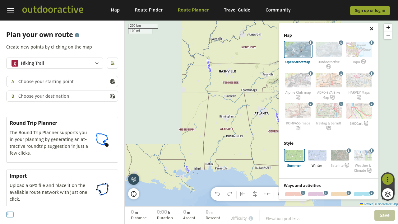
Outdooractive is built for something broader. It covers 30+ outdoor activities, offers route creation tools with distance/duration/elevation calculation, supports offline maps, and provides official topographic map layers. Weather and climate map layers are available, but they sit behind Pro+ (€59.99/year) and are interactive overlays you read and interpret yourself, not a single "should I ride this route at 8am?" score.
Neither is better in an absolute sense. They solve different problems. The question is which problem you actually have.
Route planning workflow: how you build a ride
Both apps let you create and manage routes, but the experience and emphasis differ.
With Tailwind GPS, you can draw routes directly on the interactive map (snap-to-roads or freehand), import GPX files, or connect your Strava account so your existing routes appear automatically. Once routes are saved, you swipe between them and scroll through departure times to compare scores. The whole workflow is browser-based, so there's no app to download. On the free plan, you can save up to 3 routes; subscribers get up to 40. The Tailwind GPS free plan is a good starting point to see how the scoring workflow fits your habits before committing.
Outdooractive's Route Planner lets you set start/end points and waypoints on the map, generates an elevation profile, and calculates distance and duration. It also supports round-trip planning and syncs with the mobile app. GPX export is available, though full functionality is tied to membership. The interface is more feature-rich for exploratory route building, which suits hikers and multi-sport users as much as cyclists.
One practical friction point: if you've already built your regular loops in Strava or Komoot, Tailwind GPS's Strava integration means zero rebuilding. Outdooractive has its own route library but the connection to third-party route sources is less seamless.
Weather and wind: what you actually get
This is where the two apps diverge most sharply.
Tailwind GPS analyses weather along the entire route, sampling conditions at each segment hour by hour. It accounts for wind direction relative to each segment's compass bearing, so a westerly wind registers as a tailwind on an eastbound stretch and a headwind on the return leg. The app then calculates headwind, tailwind, and crosswind percentages across the full ride, weighted by distance. You get a single score per departure hour, plus a breakdown of what to expect segment by segment. It's a route-specific weather forecast for cyclists, not a forecast for your postcode.
Outdooractive offers Weather and Climate map layers sourced from MetGIS and ExoLabs, which are terrain-aware weather models. These are genuine tools for understanding conditions across a region. You can see temperature, precipitation, wind, and snow layers on the map. The limitation for cycling is that these are layers you visually interpret; there's no translation step that converts those layers into a route-specific suitability score for a specific departure time. You might see that there's a westerly wind at 20 km/h, but working out whether that's mostly a tailwind, mostly a headwind, or mostly a crosswind on your specific loop, at the time you'll actually be riding each segment, requires manual mental effort.
That translation gap is the core difference. Wind direction arrows on a map aren't the same as route-specific wind impact at your ETA. Tailwind GPS does that calculation for you; Outdooractive leaves it to you.
Decision support: "should I ride today, on this route, at this time?"
Here's a practical example. Say you have two options: your usual 40 km road loop and a shorter 25 km gravel route. It's Friday evening and you're deciding whether to ride Saturday morning or Sunday morning, and whether to go early or later.
With Tailwind GPS, you'd open both routes and scroll through Saturday and Sunday departure times. You might see:
- Road loop, Saturday 7am: Score 72 (Great)
- Road loop, Saturday 10am: Score 38 (Challenging)
- Gravel route, Sunday 8am: Score 84 (Excellent)
That's a complete answer. Same routes, same weekend, three different scenarios, three numbers. Should you ride today or tomorrow? Tailwind GPS makes that a two-second decision.
With Outdooractive Pro+, you'd check the wind and weather layers, observe the wind direction at the relevant times, and mentally trace your route to estimate the impact. That works if you're comfortable reading maps and weather charts, but for most recreational cyclists it's more effort than it's worth, particularly if you're trying to make a quick call on a weekday evening.
Time horizon: planning today vs weeks ahead
Tailwind GPS free users can see 3 days ahead. Subscribers unlock a 14-day planning window, which changes how you can use the tool entirely. With two weeks of scored forecasts, you can identify the best riding day of the whole next fortnight, plan a training block around quality days and deliberate headwind sessions, and lock in a sportive start time that aligns with peak conditions.
Outdooractive is excellent for planning the routes themselves, which you might do months in advance regardless of weather. Its weather layer functionality is subscription-dependent and the forecast horizon specifics aren't clearly documented as a headline feature in the way Tailwind GPS's 14-day window is. If long-range cycling wind planning is your priority, the forecast depth in Tailwind GPS is a genuine differentiator.
Offline maps, navigation, and getting you there
This is Outdooractive's clearest strength for cyclists who ride in unfamiliar terrain. Pro+ users can download offline maps and use turn-by-turn navigation, which matters when you're somewhere with no signal. The official topo layers also make it genuinely useful for off-road, gravel, and bikepacking routes where terrain matters as much as wind.
Tailwind GPS is browser-first. You plan and score your routes in the browser, draw new ones on the map, import and export GPX files, and follow saved routes with turn-by-turn guidance and voice prompts when you have a signal. You can also export a GPX to load onto your Garmin, Wahoo, or other GPS computer if you prefer a head unit. That workflow suits most road cyclists and gravel riders, whether they navigate from their phone or a dedicated device.
The practical question: are you trying to maximise ride quality before you leave, or do you need offline maps to guide you with no signal? Tailwind GPS handles the former and offers online browser navigation; Outdooractive is stronger for the latter.
Pricing: what you pay for
Tailwind GPS has one of the most accessible free plans available: 3 saved routes, 3-day forecasts, GPX import/export, Strava sync, route drawing, and route sharing, all free. The subscriber plan is $2.99/month or $19.99/year and adds 40 saved routes, 14-day forecasts, weekly ride summary emails, route-specific alerts, wind score notifications, and rain alerts during your preferred riding windows.
Outdooractive Pro is €29.99/year and Pro+ is €59.99/year. Weather and Climate layers require Pro+. Official topo maps and offline navigation are also Pro+ features.
If you're primarily interested in wind/timing intelligence for cycling, Tailwind GPS's annual plan costs less than €20 and solves that problem directly. Outdooractive Pro+ costs three times as much and delivers the weather layers as one component of a much broader outdoor platform. If you mainly want offline maps, topo layers, and multi-sport route planning, that wider platform may well be worth it. If your main question is "which route, what time?", the cost-per-problem-solved calculation favours Tailwind GPS.
For subscribers who want to use headwind sessions deliberately for training, Tailwind GPS also has a headwind training mode that surfaces routes with sustained headwinds. That's a feature with no equivalent in Outdooractive. More on that in training effectively in headwinds.
Full feature comparison
| Tailwind GPS (Free) | Tailwind GPS (Subscriber) | Outdooractive (Free) | Outdooractive (Pro) | Outdooractive (Pro+) | |
|---|---|---|---|---|---|
| Wind-aware scoring (0–100) | Yes | Yes | No | No | No |
| Departure-hour recommendations | Yes | Yes | No | No | No |
| Route segment wind breakdown | Yes | Yes | No | No | No |
| Personalised to riding speed | Yes | Yes | No | No | No |
| Forecast window | 3 days | 14 days | - | - | Limited/subscription-dependent |
| Weather map layers | No | No | No | No | Yes (MetGIS/ExoLabs) |
| Alerts (score, wind, rain) | No | Yes | No | No | No |
| Weekly ride summary | No | Yes | No | No | No |
| Strava sync | Yes | Yes | No | No | Limited |
| GPX import | Yes | Yes | No | Yes | Yes |
| GPX export | Yes | Yes | No | Yes | Yes |
| Offline maps | No | No | No | Yes | Yes |
| Official topo maps | No | No | No | No | Yes |
| Route planning interface | Yes | Yes | Yes | Yes | Yes |
| Saved routes | 3 | 40 | Limited | More | More |
| App required | No (browser) | No (browser) | No | App + web | App + web |
| Price | Free | $2.99/mo or $19.99/yr | Free | €29.99/yr | €59.99/yr |
Who should choose Tailwind GPS
Tailwind GPS is the better fit if:
- You want to know the best departure time for a specific route on a specific day
- You're trying to avoid headwinds on a bike ride or deliberately seek them out for training
- You already use Strava and want your routes scored automatically
- You ride regular loops and want a quick daily check rather than building new routes from scratch
- You value a simple, mobile-friendly interface over a feature-dense mapping platform
It's probably not the right tool if your main priority is topo maps, multi-activity planning across hiking and skiing, or turn-by-turn offline navigation.
If you're already using Komoot or Strava for route building, Tailwind GPS sits alongside them cleanly. You plan the route in your preferred app, export or sync it to Tailwind GPS, and get the wind/timing intelligence on top. Wind scores for your Strava routes is exactly this workflow.
Who should choose Outdooractive
Outdooractive is the better fit if:
- You want a single platform for planning, navigating, and logging rides across multiple outdoor activities
- Offline maps and reliable navigation in remote areas are a priority
- You want official topographic maps for off-road and gravel riding
- You're happy to interpret weather layers yourself and don't need a route-specific departure-hour score
It's not well-suited if your specific question is: "should I leave at 7am or 9am to avoid the headwind on the back half of my regular loop?" That question doesn't have an answer in Outdooractive, even on Pro+.
The most practical setup for many cyclists: use Outdooractive for route discovery and building, export via GPX, and run the route through Tailwind GPS for wind and timing scoring before you leave. The two tools don't compete directly so much as they complement each other, with one solving the map problem and the other solving the conditions problem.
FAQs
Do I need Outdooractive if I use Tailwind GPS?
Not necessarily. Tailwind GPS has its own route drawing tool, GPX import, and Strava sync, so for cyclists with existing routes, it's self-contained. Outdooractive adds value if you want offline navigation, topo maps, or multi-activity planning.
Which app shows weather along the whole route vs at one location?
Tailwind GPS analyses conditions along your entire route, segment by segment, personalised to your pace. Outdooractive's weather layers show regional conditions on a map, which you then interpret manually.
Do I need a subscription for wind-related planning?
On Tailwind GPS, the free plan gives you a 3-day forecast with full scoring. Subscribers unlock 14 days, alerts, and more saved routes. On Outdooractive, the weather/climate layers that are most relevant to cycling conditions require Pro+ (€59.99/year).
Can I import/export GPX files and sync routes?
Yes, both platforms support GPX import and export. Tailwind GPS also offers Strava sync, which pulls in your routes automatically. Outdooractive GPX functionality is available on paid plans.
Which is better for offline riding?
Outdooractive. It has dedicated offline map downloads and turn-by-turn navigation built for use without a signal. Tailwind GPS is a browser-based planning tool; for the ride itself, you'd export a GPX and use a separate GPS device.
What's the biggest difference between a weather map and wind-aware ride scoring?
A weather map shows you what the wind is doing across a region. A wind-aware ride score tells you how that wind will affect your specific route at the specific time you plan to leave, accounting for each segment's direction, your pace, and where you'll be on the route at each hour. The wind-aware cycling apps compared guide goes deeper on this distinction if you want the full breakdown.
Related posts

Introducing Ride Huddles: a simple way to choose your next group ride
Ride Huddle is a simple way for groups to choose a route together. Create a Huddle, add your routes, share one link, and let everyone vote — free, with no account required.
·2 min read

How to navigate a cycling route without getting lost
Stay on the line with in-browser turn-by-turn: voice prompts, navigate-to-start, and rerouting. Tailwind GPS is the phone navigation — export GPX only for a head unit.
·8 min read

How to plan a cycling route and navigate it on your phone
Plan a cycling route on your phone, pick the best hour, then start in-browser turn-by-turn. Tailwind GPS includes voice prompts, navigate-to-start, and rerouting.
·6 min read