Tailwind GPS vs MapMyRide: which is right for your rides in 2026?
Tailwind GPS vs MapMyRide compared for cycling route planning. See which app wins on wind forecasting, departure timing, tracking, and more.

You've got a ride window coming up. You know the routes. You just don't know which one to ride, or when to leave. So which app actually answers that question?
That's the heart of the Tailwind GPS vs MapMyRide comparison, and the answer depends entirely on what you're trying to solve.
Quick verdict: which one should you use?
Here's the 10-second version:
- Choose Tailwind GPS if you want to know which route will feel best today, which departure hour gives you a tailwind, and whether rain is going to catch you on the back half.
- Choose MapMyRide if you want to track your rides, follow structured coaching, share your live location, and analyse performance over time.
Both apps let you plan and save routes. Both will help you get out on the bike. But they diverge sharply the moment you ask: "Given the wind forecast, when should I actually leave?" That's a question MapMyRide wasn't built to answer. Tailwind GPS was built to answer nothing else.
What MapMyRide does well

MapMyRide describes itself as "the top-rated cycling GPS app with 90M+ users", and that scale is genuinely impressive. The platform has built a broad and loyal user base around a core workflow that works well: plan a route, go ride it, get your stats afterwards.
The routes section lets you create your own routes or discover existing ones, with links to city-specific pages that make finding a local loop reasonably straightforward. You save routes, then head out with the app tracking your position, speed, and distance.
The real depth is in the paid MVP tier. MapMyRide's MapMyRide MVP vs free upgrade highlights features like live tracking, audio coaching, and performance insights. If you're working through training programmes, want someone (or something) to guide your effort in real time, or want to share your location with a family member for safety, the MVP plan pulls those together in one place.
Post-ride, MapMyRide gives you the kind of analysis that helps you improve. That feedback loop, plan, track, review, is genuinely useful for riders focused on getting faster or building fitness.
What Tailwind GPS does well: the ride conditions problem
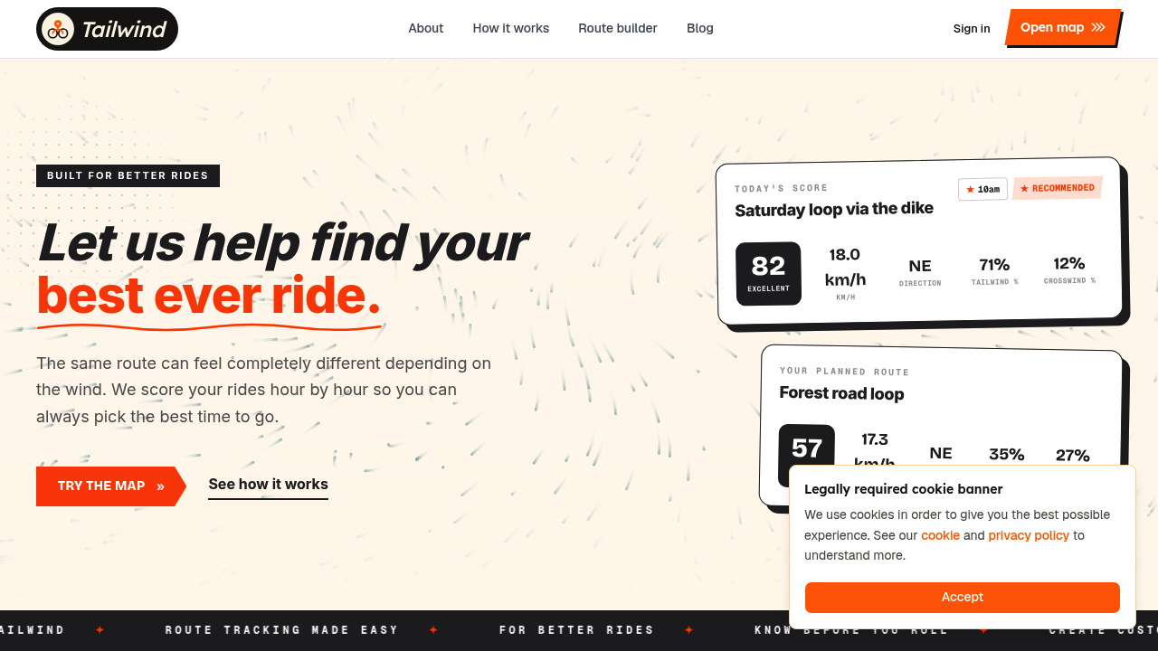
Tailwind GPS exists to answer one question: where should I ride, when should I leave, and which route will give me the best experience?
The way it does that is through the Tailwind Score (0-100), assigned to every route for every departure hour. The score bands break down like this:
- 80-100: Excellent. Expect favourable tailwinds for most of the ride.
- 55-79: Great riding conditions.
- 40-54: Neutral.
- 20-39: Challenging.
- 0-19: Prepare for a tough ride.
That single number covers wind direction and speed, temperature, rain probability, and your expected position on the route at each point in time based on your riding pace. It's not a forecast for your front door. It's a forecast for your entire route, segment by segment, matched to where you'll actually be.
Free users can plan three days ahead, while subscribers unlock a full 14-day cycling weather forecast. That planning horizon is a real differentiator if you're trying to schedule a long ride around a good weather window.
Beyond the score, Tailwind GPS sends you active notifications: weekly ride summaries, route-specific email alerts when a saved route hits a score threshold you care about, and route-specific rain alerts during your preferred riding hours. You set your preferences once, and the app watches the forecast for you.
There's also a headwind training mode, which deliberately highlights routes with sustained headwinds. So if you want to build strength rather than optimise for comfort, the score works in reverse: high headwind days become training opportunities rather than reasons to stay home.
Side-by-side comparison
| Feature | Tailwind GPS | MapMyRide |
|---|---|---|
| Route creation | Yes (draw, snap to roads, freehand) | Yes (route builder) |
| Route discovery | Via interactive wind map | Discover routes by city |
| Saved routes | Up to 3 (free) / 40 (subscriber) | Yes |
| Navigation/export | GPX import and export | GPX export available |
| Tracking and training insights | Not a tracking app | Core feature |
| Audio coaching | No | Yes (MVP) |
| Safety / live tracking | No | Yes (MVP) |
| Weather along the route | Yes, segment-by-segment | General conditions only |
| Wind headwind/tailwind analysis | Yes, route-specific score (0-100) | Not presented as route-specific scoring |
| Multi-day planning window | 3 days (free) / 14 days (subscriber) | Not a core feature |
| Departure-time guidance | Yes, per departure hour | No |
| Email alerts for conditions | Yes (score thresholds, rain alerts) | No |
The overlap is real: both apps support route building, both have free tiers, and both can export files you can use on a bike computer. But the gap opens up entirely on the wind and timing rows. Tailwind GPS was designed for conditions planning; MapMyRide was designed for tracking and performance.
The key gap: weather at one spot vs wind where you'll actually be
This is worth spelling out because it's the thing that generic forecasts consistently get wrong for cyclists.
A southwest wind at 20 km/h sounds fine. But if your route heads southeast for the first 25 km and then loops back northwest for the return, that same wind becomes a brutal direct headwind home. A forecast for your postcode won't tell you that. A route-specific tool does.
Tailwind GPS divides each route into segments and samples hourly wind forecasts along the route, accounting for your riding speed to match the forecast to where you'll be at each point in time. The result is a cycling weather along your route forecast rather than a static pin on a map.
MapMyRide's strength lies elsewhere. Its route planning and tracking tools are well-built, but for wind-segment scoring and departure-time optimisation, you'd need to look at a separate tool. Third-party apps like Epic Ride Weather do offer route-specific forecasting that works alongside MapMyRide routes, but that's an additional integration step rather than something baked in.
Scenario: 90 minutes after work on a Tuesday
You've got two options saved. A flattish out-and-back along the valley, and a more exposed loop over open farmland that normally feels faster but gets hammered when the wind is from the west.
With Tailwind GPS: You open the app, glance at both routes, and see the valley route is scoring 74 at 5pm and 61 at 6pm. The exposed loop is scoring 38 at 5pm and 52 at 6pm. Easy call: valley route, leave at 5pm. If you'd set an alert, you'd have already known this at lunchtime.
With MapMyRide: You'd plan the route, start tracking when you leave, and get coaching and stats during and after the ride. What you won't see before you roll out is which of those two routes is going to feel better at 5pm given the forecast.
Neither approach is wrong. They're solving different problems.
Integrations and getting set up
For Tailwind GPS Strava integration, you simply connect your Strava account and your existing routes load automatically. No rebuilding anything. Within minutes, each route has a wind score for the coming days. You can also import GPX files, draw new routes directly on the interactive map, and share route links. The interactive route planner map works in the browser, so there's no app download required.
For MapMyRide, the mobile app is central to the experience. Route planning, coaching, and live tracking all sit inside it. If you use a dedicated bike computer, MapMyRide export GPX routes functionality means you can transfer routes across without re-creating them.
Many cyclists use both workflows: plan and draw routes in one tool, export the GPX to a Garmin or Wahoo for on-bike navigation. Both apps support that reality, so there's no either/or on the device side.
Which should you choose?
Choose Tailwind GPS if you:
- Get caught out by headwinds on routes you thought you knew
- Want to plan rides around the best time to ride based on the forecast
- Value a 14-day planning window for scheduling around good conditions
- Want email alerts when your favourite route hits a score worth getting excited about
- Like the idea of headwind training days built into your planning rather than bolted on separately
Choose MapMyRide if you:
- Primarily want to track rides and review performance data afterwards
- Want live audio coaching during your ride
- Use live location sharing for safety
- Enjoy community challenges and leaderboards
Use both if you: want the full picture. MapMyRide handles tracking and performance; Tailwind GPS handles the conditions decision before you even clip in. They don't overlap on the things that matter most, which makes them genuinely complementary.
Tailwind GPS's free plan includes route saving, 3-day forecasts, route drawing, GPX import and export, Strava integration, and the interactive wind map. It costs nothing to try, and most riders find the answer to their first "should I go now or at 5pm?" question within a few minutes of signing up.
Frequently asked questions
Can I plan around wind and rain with either app?
Tailwind GPS is built specifically for this. You get a route-specific wind and rain probability forecast, hour by hour, with a single score per departure hour. MapMyRide is focused on tracking and coaching; detailed wind-segment forecasting isn't a core feature.
Which one should I use on weekdays when time is tight?
Tailwind GPS. When you've only got a narrow window, knowing that 5:30pm has a score of 78 and 6:30pm has a score of 44 on your usual route makes the decision instant. MapMyRide is better suited to tracking the ride once you're underway.
Does Tailwind GPS work with Strava routes?
Yes. Connect your Strava account and your saved routes import automatically. You can also draw new routes or upload a GPX file if you've got something that's not on Strava yet.
Do I need a subscription for wind planning?
No. The free plan includes 3-day forecasts, route saving, GPX import and export, Strava integration, and the interactive wind map. A subscription (from $2.99/month) unlocks the full 14-day planning window, route-specific email alerts, and the ability to save up to 40 routes.
Can I export routes as GPX from both apps?
Yes. Both Tailwind GPS and MapMyRide support GPX export, so you can send routes to a Garmin, Wahoo, or any other device that accepts GPX files.
Try it now
Connect Strava, compare departure-hour scores on your usual routes, and pick the best window before you roll out.
Related posts

Introducing Ride Huddles: a simple way to choose your next group ride
Ride Huddle is a simple way for groups to choose a route together. Create a Huddle, add your routes, share one link, and let everyone vote — free, with no account required.
·2 min read

How to navigate a cycling route without getting lost
Stay on the line with in-browser turn-by-turn: voice prompts, navigate-to-start, and rerouting. Tailwind GPS is the phone navigation — export GPX only for a head unit.
·8 min read
How to plan a cycling route and navigate it on your phone
Plan a cycling route on your phone, pick the best hour, then start in-browser turn-by-turn. Tailwind GPS includes voice prompts, navigate-to-start, and rerouting.
·6 min read